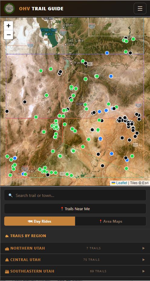
Give residents and visitors a live, GPS-enabled trail guide — branded with your logo, backed by monthly analytics, ready in weeks. All you need is a GPS track recorded on your phone and a description. We do the rest.
We build and maintain the maps. You share the link. Riders track live in the backcountry — with your organization's brand on every screen.
Record a GPS track on your smartphone and write a short description — or a long one. That's it. We handle everything else. Already have a printed map you like? Send it to us and we may be able to use that too.
We skin the app with your organization logo and colors and generate branded QR codes for posters, kiosks, and social media. Scanning leads riders straight to your organization's trail guide.
Every month you receive a plain-English report: how many riders used the guide, which trails were most popular, where QR scans came from, and how you compare to last month.
Built for the backcountry — where cell signal ends and accurate navigation matters most.
Riders see their exact location overlaid on calibrated trail maps — no signal required once maps are downloaded. Works on the most remote terrain.
Full-resolution GeoPDF maps download to the device before the trip. No data plan, no roaming charges, no dead zones — just accurate maps when it matters.
Organization logo, colors, and welcome splash replace the default branding. Scan a QR at a kiosk and the app opens as your organization's Trail Guide — not a generic app.
How many sessions, which trails, where QR codes were scanned, organic vs. paid social traffic — delivered to your inbox on the 1st of every month, ready for board presentations.
Riders submit trail conditions directly from the app — with GPS-tagged photos and a condition dropdown. You see them in real time in the admin panel, organized by trail and date.
One platform covers OHV, Mountain Bike, Hiking, Gravel, Snowmobile, and Equestrian — each activity gets its own difficulty scale, trail metadata, and filtering. Launch OHV today, add MTB next season.
Every trail offers GPX and KML file downloads so riders can load routes into Garmin, onX, or any navigation device. One tap, no account required.
Trails tagged with width limits, surface type, and vehicle classes. Riders filter instantly — so a 60" side-by-side never ends up on a 50" trail.
Organization-specific QR codes with your logo embedded — print-ready for kiosks, brochures, and social posts. We generate them; you put them where riders are.
Conditions change fast in the backcountry. New trails get built, old ones wash out, seasons close access, and emergencies happen without warning. A printed map or a stale app can send visitors somewhere they shouldn't be.
With Trusted Trail Maps, we can update your maps in days — not months. You call us, we handle it.
We'll mark it closed or update the route within days so no one rides into a dead end.
Mountain goats having babies, nesting raptors, seasonal snow — we'll post the closure and remove it when it's lifted.
Getting accurate access information in front of visitors fast is exactly what we're built for.
Record a GPS track on your phone, send us a description, and we'll have it on the map in days.
Whether you're a organization tourism board, an OHV club, or a state recreation department — we speak your language.
Every client gets a monthly analytics report they can bring to a board meeting or grant committee — no data science required.
We automatically cluster scan GPS coordinates so you see exactly where riders found your code — kiosk, event, social post — without manual tracking.
Guided map sessions per trail, average time on map, return visitor rate — the numbers that prove your trails are being used.
How many riders downloaded each trail's offline map, broken out by trail and month — perfect for demonstrating reach to sponsors and grantors.
Reach, clicks, and CTR per post across Facebook, Instagram, and YouTube — organic vs. paid split so you know what's actually driving riders to the app.
We'll show you the live app with your organization's trails, walk you through the analytics dashboard, and answer every question before you commit to anything.
Most organizations are live within 2–3 weeks of signing.
Submit map change requests, upload new GeoPDFs, or report an issue through our client portal.
Open Client Portal →